

East Iceland is one of the regions of the island that tourists visit the least. Although it may seem a bit forgotten, omitted, or unattractive, East Iceland has a lot to offer. You can find there, among other things, picturesque fjords, breathtaking views, and hundreds of waterfalls. Here is the longest lake in Iceland, where the “sister” of the Loch Ness monster is said to live. There is also the largest forest on the island.
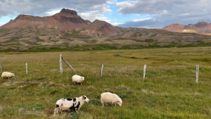
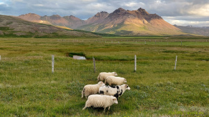
East Iceland has fantastic flora and fauna. You can find herds of sheep, puffins, and reindeers here. The climate is mildest in East Iceland, and in the summer months, there are some warm days, which is an exception compared to the rest of the island. It is also a region where earthquakes are less frequent than in the rest of the country.
East Iceland – going North of Hofn
Hofn – Road no. 1 – Djupivogur – Gledivik – Route no. 939 – Egilsstadir
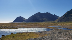
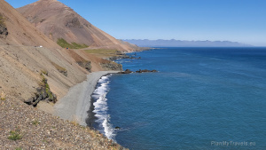

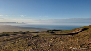
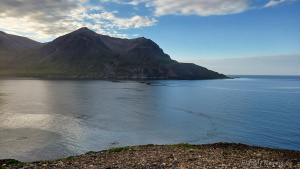
East Iceland begins with the town of Hofn. Next, National Road No. 1 leads north to the island. The route from Hofn follows the ocean’s coastline. It is worth taking your time on this road as the views are fantastic. There are several small coves along the route where you can park and enjoy the views. It is also worth stopping in a few small towns along the way.


Djupivogur
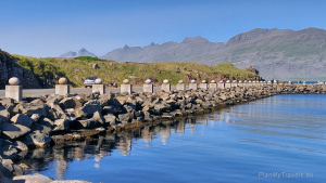
Although Djupivogur is a small settlement, it is very picturesque, situated between two fjords. It has one of the most important fishing ports on the island and one of the oldest commercial ports in Iceland, dating back to the 16th century.

Old, historic houses also attract attention. The oldest house (the red building) was built in 1780, and the next (the black one) in 1848. One of them houses a small museum and a restaurant.

In 2013, Djupivogur joined a small group of Cittaslow cities – the International Network of Cities where Living is Good. The inhabitants of Djupivogur pay special attention to protecting the environment, promoting local products, and improving the quality of life.
It is worth stopping for lunch here. The Framtid Hotel restaurant guarantees a table with a view of the bay and mountains and offers tasty local delicacies.

When leaving town, it is worth paying attention to the mountain with a perfect pyramid shape (1069 m above sea level), which is the symbol of Djupivogur.

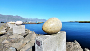
Gledivik
A few kilometres outside the town of Djupivogur, it is worth stopping in the small village of Gledivik, commonly known as “Merry Bay.” There, you can see an example of contemporary art. The granite sculpture “The Eggs of Merry Bay” by Sigurd Gudmundsson depicts 34 bird eggs that nest in Iceland. One of the eggs is a different colour and symbolises the red-necked diver, considered the ornithological symbol of Djupivogur. It is a quaint tourist attraction.
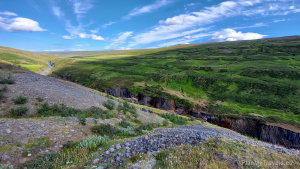
Route 939 – “hidden treasure”
If you have time and do not have to get anywhere at a specific time, it is worth taking the main road No. 1 onto the local road 939. That is a variant of the route that will give you a pleasant surprise. Although you won’t find a description of this route in tourist guides, I think it’s worth making this trip. East Iceland offers many roads similar to Road No. 939. If you reach this region, it is worth staying longer.

Because road 939 is gravel and bumpy, it can only be travelled by 4WD cars. This route is approx. 30 km long. You enter the top of the mountain range at an altitude of about 500 meters above sea level. It’s a great tour and has breathtaking views. Along the way, you can see a dozen waterfalls, small swift streams and flocks of sheep. This road is rarely travelled, so you’re likely to be there alone! Silence is everywhere, with the sky on all sides reaching as far as the horizon.


Egilsstadir
East Iceland has only one large city, Egilsstadir, which is unofficially known as the eastern capital. In 2021, this small town had a population of just over 2,500.
The city has developed well in agriculture and industry, and in recent years also in tourism. It has a well-developed commercial network and accommodation facilities, including hotels and campsites. The town also has a large swimming pool and a golf course. There are several clubs here: jazz, theatre, opera studio, and city choir.
Egilsstadir is also well connected to the rest of the country. The bus can take you to the north (Akureyri) and the west (Reykjavik). There is also an airport that mainly serves domestic flights, but it serves as a substitute for international flights in an emergency.
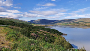
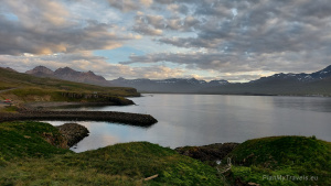
This place’s great attractiveness is influenced by its location on the eastern shore of Lake Lagarfljot. Legend has it that in the waters of this lake lives a monster, the sister of the famous Loch Ness monster.

There are many smaller rivers and streams in the area where you can fish, for example, salmon and trout. That makes Egilsstadir increasingly popular among tourists and fishing enthusiasts.
The largest campsite in this part of Iceland is immensely popular. Its great advantage is a well-developed sanitary facility with access to a shared kitchen and laundry room. People who do not live at the campsite can also use the laundry. Just take a handful of coins to start the washing machine and dryer. The same fee applies to washing and drying. For each service, pay the equivalent of 800 KR (approx. 25 PLN).
Camping Egillstadir is open year-round. More about the campsite on the campegilsstadir website.


Around Lagarfjlot Lake
Egilsstadir – Route 931 – Route 910 – Hydroelectric power station – Route 923 – Road no. 1 – Egilsstadir


When visiting East Iceland, take a drive around Lagarfjall Lake. That is a half-day trip (4-5 hours). When you start your journey from Egilsstadir, take route no. 931.

The lake’s vicinity is very picturesque, devoid of urban buildings, and quite austere, which makes it truly beautiful.

There is also a tourist information point on the route, with a story about the lake monster and a list of the dates when locals saw him in the lake.


The route then runs along Road 910. It is worth taking this road slowly, without haste. Be careful, especially since the sheep “rule” the area and often walk in the middle of the road.


Along the way, numerous smaller and larger waterfalls, rushing rivers, and endless “wilderness” with large boulders scattered around.

This place, called Nordastafell, is part of the stories described in the Icelandic Saga.


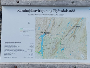
Hydroelectric power station Kárahnjúkar

A dozen or so kilometres behind the lake, you reach the place where there is an impressive and very modern hydroelectric power plant – Kárahnjúkar Hydropower Plant. There is an imposing dam on the shores of a Halslon reservoir. It is 730 meters long, almost 200 meters high, and is the largest structure of this type in Europe. The power plant was opened in 2009. It was built by the country’s largest aluminium smelter, located 75 km away. The smelter belongs to the second-largest aluminium producer in the world – the Alcoa Fjardaál concern.


It is a high-level technical achievement that perfectly uses renewable energy sources. The power plant project was complex and challenging to implement. It required separating the two largest rivers flowing from the Vatnajökull glacier with five dams and creating three reservoirs. The water from the reservoirs flows through a 40 km-long tunnel carved into the rock. At the end of the tunnel, the water descends 600 meters, driving six large electric turbines inside the Vatnajökull glacier. The water flow is 144 m³/s.


Walking the dam
When seen up close, the dam is very impressive. You can not only drive your car over the dam, but there is also a safe walking path. The dam’s ridge can be walked along its entire length. Therefore, the entire structure can be seen from a close distance while standing on its top. It’s an outstanding experience. There are no tolls, as crossing the dam is part of the 910 route, where standard traffic takes place.

After crossing the dam, Road No. 910 becomes very demanding, with very gravelly, bumpy sections. It is worth having a car with a powerful engine and 4-wheel drive. This section of the road leads to the top of the mountain range, almost 800 m above sea level.
The route continues as Road No. 923. Several points along this road offer views of beautiful canyons and waterfalls.
Basalt Canyon – Stuðlagil Canyon
The Stuðlagil Canyon is considered the “diamond of nature” of East Iceland. It was discovered by tourists quite recently, in 2007, after the construction of the Kárahnjúkavirkjun hydroelectric power plant. The postglacial river that once flowed through the canyon has been diverted by the Kárahnjúkar dam, lowering water levels and exposing the canyon’s basalt walls.
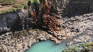
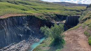
The stretch of the Stuðlagil River is considered home to Iceland’s most extensive collection of basalt columns found on land. The canyon is 500 meters long, and basalt columns are on both sides of the river. Their height reaches up to 30 meters. The colour of the river in the canyon varies depending on the season. During summer, it has shades of blue-green, but when the dam is overfilled with water and snow is melting, the water turns grey-brown.


Road 923 leads to the canyon, with parking lots at both ends. You can see the canyon from both river banks and go down to its bottom. Viewing the canyon from Road No. 923 is convenient. An observation deck at the end of the walking path offers views of both sides of the river.
Where to cross the canyon
You can also view the canyon from the other side of the river, but this tour requires a long walk. To get to the place where the basalt columns exist, you need to walk for about 5 km along the canyon’s edge (one way). However, this option is worth using because there are fewer tourists on the other side of the river, and you can see this beautiful place from a different perspective. Being on that side of the canyon allows one to descend to its bottom and swim in the river.
Below is a map showing the locations of the two car parks.

The canyon is truly phenomenal and worth seeing. Even when crossing National Road No. 1, it is worth making up for that road because there aren’t many such places on Earth.
Rjukandi waterfall
Returning to Egilstadir on National Road No. 1, it is worth stopping by a few waterfalls. There are a lot of them here. Some of them can be seen directly from the road. We stopped at the Rjukandi waterfall. It is 139 meters high, and you can easily reach its top via a marked path.


East Iceland – the land of puffins
Egilsstadir – Route 94 – Vatnsskard Storurd – Njardvik Screes – Borgarfjörður Eystri – Bakkagerði – Egilsstadir
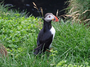
East Iceland is a favourite nesting place for puffins, water birds that lay eggs on cliffs and raise their chicks yearly. Seeing those birds here is a real treat, as this species occurs in only a few places worldwide.

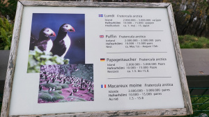
Puffins inhabit the islands, shores, and waters of the Northern and Central Arctic Oceans. Despite the large population, its species is threatened with extinction. Therefore, the puffin population in Iceland is under strict protection. The birds can be seen from a distance or on dedicated wooden terraces. However, it is not allowed to go to the places where their nests are located.
Puffins elicit strong sympathy due to their funny, lovable appearance. It is easy to like them: a small red curved beak, a large round head, white and grey plumage and short red legs. Fun Fact: Scientists recently discovered that puffins’ beaks are fluorescent. The explanation might be that it helps them during the night-fishing and mating season, when they want to stand out. A true wonder. More information about puffins at puffins.is

In the vicinity of Egilsstadir, puffins are the easiest to see on the small island of Hafnarholmi, where they nest from May to mid-August. Road no. 94 leads there. You pass herds of sheep, high mountains, green meadows, and beautiful cliffs on the way. Travel time from Egilsstadir is approximately 1 hour each way.


Route no. 94
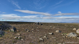
Route No. 94 is gravel and leads through the mountain tops. You enter it at an altitude of about 500 meters above sea level. On the way, it is worth stopping at the magnificent viewpoint of Vatnsskard-Storurd.

From this place, you can see the ocean shore, mountains, and valleys. I recommend it!


At the end of Road No. 94, there is a tiny bay, harbour and the island of Hafnarholmi. There is a small observation deck on-site from which you can admire these extraordinary birds.


Borgarfjörður Eystri
On the way back, we had a short stop in Borgarfjörður Eystri, also known as the Icelandic capital of puffins. This tiny village, with a population of around 100, has a lot to offer. There is, among others, a small port from which you can take a boat to the island where puffins nest. Such an expedition allows the puffins to be seen up close – from less than 2 meters away.

Borgarfjörður Eystri also prides itself on having the most inhabited Elvish settlements in this region of Iceland and a nice variety of hiking trails. That area not only boasts spectacular scenery but also offers a good selection of accommodations and services in the village of Bakkagerði. Borgarfjörður Eystri is Iceland’s northernmost fjord. It is only an hour away from National Road No. 1, but it is a place very rarely visited by tourists. That makes it attractive: no crowds, silence, beautiful nature and breathtaking views.


The village of Bakkagerði also has a small church and a charming turf-roofed cottage, the Lindarbakki Turf House.

The oldest parts of this house are over 120 years old. Lindarbakki Turf House is still inhabited and serves as a summer house. The last owner, an elderly lady, Elísabet Sveinsdóttir, also known as Stella, lives there from May to August. When you knock on her door, she gladly shows you her house to tourists.


You can read more about the Borgarfjörður Eystri region on the website borgarfjordureystri. is.

Njardvik Screes

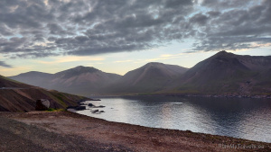
We returned to Egilstaddir during sunset. The road on the ocean’s shore, the setting sun, the mountains, and the distant horizon in the background are unforgettable impressions. There was a feast of beautiful colours, single rays of the sun scattered by the clouds, and light reflections in the calm waters of the ocean—amazing views and magical moments.

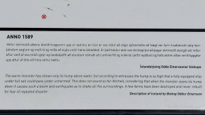
The section of Road No. 94 between Njarðvík (Stórurð Trail Head) and Bakkagerði, called Njardvik Screes, makes a great impression on this route. Right on the ocean’s shore, this narrow road opened in 1950. Previously, that section of the road could only be travelled on foot or horseback. The road was dangerous, mainly due to frequent avalanches, landslides and the slippery surface covered with volcanic ash. This road was also very dangerous for another reason. A monster named Naddi lived in a cave hidden in the nearby mountains. It was half-human (waist up) and half-animal (waist down).
The monster attacked travellers, robbed their belongings, and killed them many times as well. After many years of torment, the monster was killed by a local farmer. He managed to push it into the ocean.
The Story of the Wooden Cross
In memory of those who died at the hand of that creature, the farmer put a wooden cross on the road. In this way, he paid tribute to the fallen. On the cross, he placed an inscription in Latin: “You who are passing here, get down on your knees before the cross in this place and humbly show the sign of Christ worship.” The legend says that the first cross stood there in 1306, but no records exist. The cross that stands on the road today stood in 1954, a few years after the road was opened.


There is a small bay where you can stop your car to admire this magical place in peace.
Iceland, my other post
I encourage you as well to read my other posts about Iceland
- Akureyri – Northern Iceland
- Diamond Circle North Iceland
- Golden Circle – treasures of Iceland
- Húsavík, Iceland – time for whales
- Iceland – tailor-made travel plan
- Iceland in winter – how to organise the trip
- Iceland photos
- Reykjanes Peninsula, South West Iceland
- Reykjavik Iceland’s capital city
- South Coast of Iceland
- Snaefellsnes Peninsula, West Iceland
- Troll Peninsula, North Iceland
- Winter in Iceland travel plan