

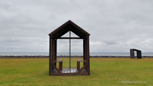
Reykjanes Peninsula
Usually, most tourists start their Icelandic adventure here. The main international airport (Keflavik) is where all international tourists land. However, few people know that the Reykjanes Peninsula is a place worth stopping at for longer. It has several interesting places worth visiting. There are, among others, geothermal wonders of nature, hot springs, a fantastic Viking Museum, a bridge suspended between two continents and breathtaking cliffs. Recently, the Fagradalsfjall volcano has become the region’s main attraction. The volcano erupted at the end of March 2021 and has delighted crowds of onlookers for several months.
It is worth adding here that the greatest attraction of the whole Reykjanes Peninsula area is nature and its unusual forms. It is simply worth driving across the peninsula. Therefore, I suggest planning two days for a peaceful tour of the entire peninsula.
In 2015, UNESCO recognized the Reykjanes Peninsula as a UNESCO Global Geopark. The Geopark covers an area of over 800 km2 and has 55 recognized geological sites. These sites play a significant role in the Geopark and are related to the history of the Mid-Atlantic Ridge and the influence of the tectonic plate movement.

Geo-stands can be single or complex objects with particularly important geological values. They can be both natural (erratic boulders, rock formations, and lava fields) and artificial (mines or quarries). You can read more about it on the UNESCO geosites website.
Keflavik


Formerly (in the 16th century), there was a large international fishing port here, where merchants from all over northern Europe came for shopping. With time (in the 17th century), the Danish monopoly on trade was introduced, and the town began to decline. After World War II, the US Army was stationed in Keflavik, but the last soldiers left Iceland in 2006. After the reconstruction of the military quarters, their function was changed, and now they mainly serve students as dormitories.
Keflavik, Troll’s Cave
Although it is an attraction prepared for the youngest, adults will also have a good time there. Inside the cave, a gigantic troll (named Skessa) sleeps, so be careful he doesn’t wake up. But don’t worry – the troll is snoring loudly, which can still be heard outside the cave, so you will know when it is a safe moment to enter 😉. The cave also has a 5XL-sized troll’s bed and armchair. Getting on the bed for an adult is a real challenge, but it is worth climbing because it helps to imagine how big the troll is. The cave can be reached from the small marina at the end of Keflavik. The path with big troll feet painted on it starts opposite the Duus restaurant. More info on the visitreykjanesbaer.is website. You can enter the cave every day between 10.00 a.m. and 5.00 p.m., and admission is free.


Stekkjarkot
is a name for traditional fishermen’s huts from the beginning of the 19th century, which were made of stone, wood, and turf. Some of them are open to the public. The huts were built in the years 1855-1924.


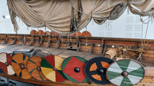
Viking World Museum


Right behind Keflavik, there is a great attraction, both for the young and old. The museum is small but very interesting. The main attraction of this museum is a replica of a Viking ship – Íslendingur (Icelandic)- and a very interesting exhibition related to the history of the settlement on the island.

There is a small cafe, a souvenir shop and a local handicraft shop.
The museum is open daily, but it is worth checking the hours before the planned visit, as these can change depending on the season. The admission ticket costs 1500 ISK (about PLN 50), and children enter for free. More information on the vikingworld.is website.


Duss by Keflavik Airport
I recommend staying at the Duus by Keflavik Airport Hotel in Keflavik for the night. This is a fantastic place, a hotel with a soul, situated right on a small marina. The hotel also owns the Kaffi Duus restaurant, which offers fantastic regional cuisine with a modern twist. It was a really great experience.


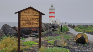
Gardur
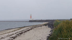
There are two lighthouses in the town of Gardur, on the Gardskaga headland. The first lighthouse dates back to 1897 and was once considered the most visible lighthouse in Iceland. Its low position meant that mists did not block the lantern’s light. At the same time, the lighthouse was not visible when high waves and a storm covered it. Therefore, over time, a second lighthouse was built right next to it in the year 1944. The new lighthouse is 28 meters high and is the tallest structure of this type in Iceland. Both lighthouses are on the UNESCO Geopark’s list of positions.
Today, this older lighthouse is after a major renovation. The property can be visited, and after visiting hours, it can even be rented for private functions. GPS data on how to get to the lighthouse: N64 ° 4 ‘54.974 “W22 ° 41’ 25.952”

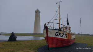
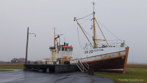
On the headland, there are also wrecks of fishing boats that can be accessed. There is a small free campsite near the lighthouse (overlooking the ocean).
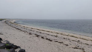
The Gardur area is a popular destination for fans of sea birds as it is home to many bird habitats. It is worth going to the small beach at the end of the headland, where you can find not only peace but also experience close contact with beautiful nature and powerful ocean waves.
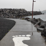
At the junction of two continents

Driving along National Road No. 425, it is worth stopping at the point where two tectonic plates meet: the Eurasian and North American ones. The canyon, which shows the place where the plates are moving apart, is marked with a symbolic 18-meter footbridge. It is worth visiting this place, as it belongs to the UNESCO Geopark sites.
GPS coordinates to get to the canyon: N63 ° 52 ‘5.558 “W22 ° 40’ 31.588”


Reykjanesta lighthouse
Reykjanesta Lighthouse is located at the top of an inactive volcanic peak. For a long time, it has served as a beacon for ships bound for the ports of Keflavik and Reykjavik. It is located on the southwestern tip of the Reykjanes peninsula, about 16 km west of Grindavik and 20 km southwest of Keflavik.
The first lighthouse in Iceland was built on the Reykjanes peninsula in 1878. Unfortunately, a few years later, it was destroyed after an earthquake. The lighthouse that can be seen today was built in 1929. It is a white concrete structure with a cylindrical shape and is 26 meters high. However, due to the lighthouse’s location, its light is located at an altitude of 69 meters above sea level, and it is a record on a national scale. Thanks to this, the lighthouse’s light range is extremely long and has a length of over 40 km (22 nautical miles).
The lighthouse is also equipped with a modern DGSP system, a GPS measurement technique that allows for greater accuracy.
This place is really worth visiting. The area around is a veritable lunar landscape, thermally active. There are thermal springs nearby and great views of the cliffs above the ocean (as long as it’s not raining and there is no dense fog). The lighthouse and its vicinity are on the UNESCO Geopark list.
GPS coordinates to get to the lighthouse: N63 ° 48 ‘54.266 “W22 ° 42’ 11.934”

Valahnúkamöl cliffs
The cliffs hide an interesting attraction. On the ocean’s shores, there is an unusual rock formation – Mount Valahn. Valahnúkur consists of layers of tuff, pillow lava and breccia. The mountain was created during a single eruption and shows examples of the different phases of the eruption.

Tuff forms during an explosive eruption, while pillow lava forms when lava explodes under water. On the other hand, Breccia is rock crushed during tectonic movements, usually re-bonded.


The cliffs are very picturesque, and the ocean is always very rough at this point. The waves hit the cliff walls with great force, causing very spectacular splashes of water. It is worth taking a walk around the area.
Road no.. 443 leads directly to the cliffs (you must pass the lighthouse). GPS data: N63 ° 48 ‘44.426 “W22 ° 43’ 0.770”

Reykjanes Peninsula and the Reykjavik area
Before you set off for Reykjavik, there are a few more interesting places to visit.
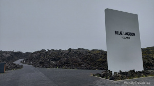
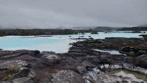
Blue Lagoon
Blue Lagoon is Iceland’s largest and most awaited tourist attraction. It is also a world-renowned spa offering hot spring baths. The water is rich in minerals and can be used for many medical treatments.

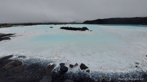
It is an unusual attraction that offers perfect rest and relaxation. Unfortunately, it can be extremely crowded and expensive in the high season.
For those who want to see the phenomenon of the Blue Lagoon and, at the same time, skip the long queue and avoid the crowd inside, it is possible to see part of the lagoon that is not commercial. You must pass the main entrance, turn left and walk around beautiful coves filled with magical blue water. The views are amazing and breathtaking. And all of this with no fees and no crowds.


I recommend using this sightseeing form if you want to see the Blue Lagoon itself. The spa and hot spring baths can be visited in many other places in Iceland. Although they are not as popular (and expensive) as the Blue Lagoon, they are equally fantastic.
Reykjanesfolkvangur Nature Reserve and geothermal natural wonders
The reserve covers an area of 300 km2 and begins approx. 40 km south of Reykjavik. The reserve was established in 1975 to protect lava rock formations. There are some interesting places worth visiting.
- Kleifarvatn Lake is the largest (10 km) and deepest (97 m) water reservoir in this part of Iceland.
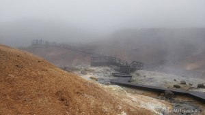
- Krysuvik geothermal area and the Seltun geothermal field are located near the lake.


When visiting the Krysuvik geothermal area, remember to cover your nose with a scarf or neckerchief. The intense and pervasive smell of sulphur (“rotten eggs”) makes it difficult to focus on anything else.

Within the geothermal area, there are paths, wooden jetties and stairs that can be safely walked over, right next to the bubbling swamps. One of the paths led to a small rushing river.

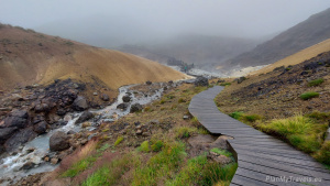

The views are surreal, out of this world, delightful, interesting, and definitely worth seeing.


National road 42 runs through the centre of the reserve, which is very picturesque and “forces” a stop at every parking lot by the road. It is a great place to see breathtaking views. If you are in this area, plan your route so that you can drive across this road and enjoy its beauty.

The whole area is crisscrossed by dozens of hiking trails, often coinciding with the old paths that lead between abandoned farms.


Krysuvikurberg cliffs
The Reykjanes Peninsula has one more wonderful place worth seeing. To the southwest of the Reykjanesfolkvangur nature reserve are the Krýsuvíkurberg cliffs, which are bird sanctuaries. These cliffs are an outstanding work of nature!
The rocks are steep, almost vertical and very high. They can be viewed from two sides. The first viewpoint is in front of the parking lot side. A thick chain hangs out there to define a safe place to stand over the cliff. Do not go behind this chain, as the cliffs slide very often. When I was visiting this place, I met a nice gentleman. He said that he has to check the places to be designated with this chain daily, as conditions change almost daily and the “conventional” safety line moves.

You can also see the cliffs at their top on the left. There is a slight hill there and a second viewpoint. After climbing it, you can see the cliff from the ocean side and thousands of birds nesting there. It is a very interesting place with amazing views.


Fagradalsfjall volcano
The volcano that erupted in 2021 is just writing its latest history. It is located on the Reykjanes Peninsula and lies between road no. 43 (leading to the Blue Lagoon), road no. 42 (next to Lake Kleifarvatn and the Krysuvik geothermal area), and road no. 427, which closes the area to the south.
The volcano woke up almost 700 years after the last eruption. Its eruption in March 2021 was preceded by increased seismic activity, which kept Icelanders awake from mid-December 2019. Several months have passed since the first fissure from which lava flowed out (August 2021). Several more fissures came, and the lava began to explode, creating spectacular fountains of fire and lava. In May, some lava fountains were projected as high as 450 meters and were visible from Reykjavik, 40 km away.
Also, in May, an attempt was made to stop the lava flow by building two 8-meter-high earth embankments. They were supposed to stop the lava from flowing into the valley and further towards road no. 427. The lava, however, passed one of the fortifications, but it did not risk flooding the road.
Due to the relatively calm and predictable course of the eruption, it has become Iceland’s biggest tourist attraction this year. It is attracting both crowds of observers and drone operators. Two hiking trails are marked out to the eruption site, starting on road no. 427.
Practical information and warnings
When visiting the Reykjanes peninsula and Fagradalsfjall volcano, be absolutely careful, heed the warnings and use common sense. Visitors are not only endangered by poisonous volcanic gases. There is also the risk of volcanic bombs falling within a radius of several hundred meters from the active crater. Volcanic bombs are a type of pyroclastic material that can be thrown into the air with great force during a volcanic eruption. Such bombs can be up to several meters long and weigh 2 tons! Additionally, some of them may explode in flight due to the expansion of their constituent gases. This is a very dangerous phenomenon, so be careful not to get too close to the volcano.
Interesting pages
Below are some interesting sites to visit. You can find maps and photos of the place where the volcano erupted.
-
- Lava field maps on the National Land Survey of Iceland website.
- For those of you who want to see the latest photos and live feeds from the volcanic eruption site, there is a nice profile of geology experts to watch on Instagram. Her name is Helga, and with passion and patience, she explains all geological processes related to a volcanic eruption, magma, gases, and chemistry. She explains everything a “normal” person has no idea about and has never heard of before but is happy to hear those stories from a wise person: Geology_with_Helga.
Iceland, my other post
I encourage you as well to read my other posts about Iceland
- Akureyri – Northern Iceland
- Diamond Circle North Iceland
- East Iceland – the land of puffins
- Golden Circle – treasures of Iceland
- Húsavík, Iceland – time for whales
- Iceland – tailor-made travel plan
- Iceland in winter – how to organise the trip
- Iceland photos
- Reykjavik Iceland’s capital city
- Snaefellsnes Peninsula, West Iceland
- South Coast of Iceland
- Troll Peninsula North Iceland
- Winter in Iceland travel plan
12 Replies to “Reykjanes Peninsula South West Iceland”