

The Diamond Circle is a tourist route that covers the most important tourist attractions in the Northeastern part of Iceland. All attractions belong to the Diamond Circle and are located near the city of Akureyri. The route is approximately 260 km long and runs along Ring Road No.1 and National Road No. 862 and 85.
Many interesting places on the Diamond Circle route are worth seeing, but I will focus on those that I consider the most interesting. The region’s attractions include Husavik and Akureyri, which I described in separate posts.
The most interesting attractions of the Diamond Circle region are:
- Jökulsárgljufur Gorge, Dettifoss Waterfall and Selfoss Waterfall
- Námafjall geothermal area, called Hverir
- Lake Myvtan and Pseudocraters
- Goðafoss waterfall
Diamond circle – the most interesting attraction of the region
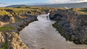
Jökulsárgljufur gorge, Dettifoss waterfall and Selfoss waterfall
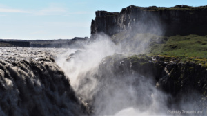
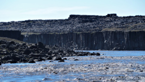
The Jökulsárgljufur gorge is the largest and most spectacular canyon in Iceland. It is 25 km long, 500 m wide and 1000 m deep.

The gorge was created by the great flood of the Jökulsá River during the last Ice Age. The Jökulsá á Fjöllum, or “Glacier River of the Mountains,” is the second-longest river in Iceland (206 km) and has its source on the Vatnajokull Glacier.
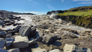
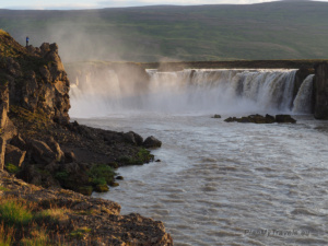
Several beautiful waterfalls are on the river. The most spectacular and most visited by tourists are the Dettifoss and Selfoss waterfalls.
The Dettifoss waterfall impresses with its great strength. It is the most powerful waterfall in Europe. Almost 200 m3 of water flow through its threshold per second! The river here is about 100 meters wide, and the height of the waterfall’s threshold is 45 meters.


Fun fact: This waterfall was used as the setting during the 2011 shooting of Ridley Scott’s movie, Prometheus.

Selfoss Waterfall is also a must-see, despite being only 10 meters high. Its charm is its width and the numerous cascades along which the river tries to reach down the canyon. The threshold of this waterfall is quite unusual. It runs along the river’s course, not across it. The entire cascade is approximately 1000 meters long.


The river also has the Hafragilfoss waterfall (27 meters high) and the Rettarfoss waterfall (7 meters high), the second of which is located in the northern part of the gorge.
In 1973, the western part of Jökulsárgljufur Canyon was declared Jökulsárgljufur National Park, and in 2008, it became part of Vatnajökull National Park.
Road to the waterfall
Dettiffos Waterfall is a 10-minute walk from the car park. From there, you can walk to the Selfoss Waterfall on a marked path along the rocky bank of the river. Distance 1.4 km, approx. 20 minutes on foot.


You can also find a marked route north towards the Hafragilsfoss waterfall from the same parking spot.
- GPS coordinates (east side) 65.819210, -16.379244
- GPS coordinates (west side) 65.813277, -16.400959
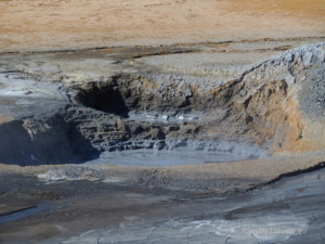
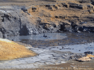
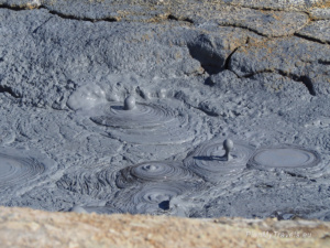
Námafjall geothermal area
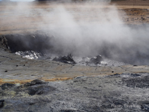
Námafjall geothermal area (also known as Hverir) is located in North-East Iceland, on the eastern side of Lake Mývatn.
Hverir is a geothermal field characterized by high temperatures, numerous fumaroles, and mud puddles. At a depth of 1000 meters underground, the water temperature is over 200 degrees C. Together with water vapour, gases reach the earth’s surface, including hydrogen sulfide, which is responsible for the suffocating smell in the air resembling rotten eggs. The hot springs produce large amounts of sulfur, which in the past was mined in Iceland and used in the production of gunpowder.


Not far from here is Iceland’s oldest and smallest power plant, Bjarnarflag Geothermal Station, which produces 3 MW of geothermal energy. Plans to expand the plant to generate 90 MW capacity are being considered, but final decisions have not yet been made.
The temperature of the water and water vapour on the earth’s surface is between 80 and 100 degrees C. When visiting Hverir, be careful and walk only along the designated paths. I would also like to add that it is not worth planning an extended stay there. Despite extraordinary views, the dominant smell of sulfur is so persistently strong that it is impossible to stay there for more than 15-20 minutes. A face scarf is a must-have set to allow you to stay there for a few minutes, but not long enough to stay longer.


- GPS coordinates for the parking lot: 65.641630, -16.807142
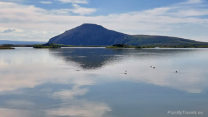
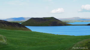
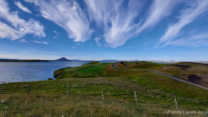
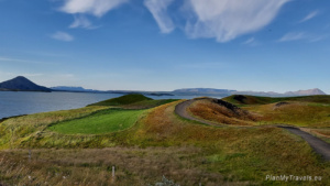
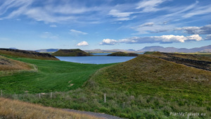
Myvatn, an extinct volcano, black fortress and pseudocraters

Lake Myvatn is the fourth largest lake in Iceland, with an area of 37 km2. The lake is also called “the lake of flies”; I advise you to remember this name well. Generally, there are so many “black flies” that you cannot get out of the car while at the lake. It is also worth keeping the car windows closed because driving with the flies inside the car will not be possible. The flies (also called midges) are highly intrusive, insistent and hungry. They do not bite, but they sting, which can result in red marks on the skin. It’s a good idea to wear long sleeves and be sure to have a head net. Without the headcover, it is impossible to function normally. Head nets can be bought in shops, restaurants and souvenir shops around the lake.
Worth knowing – flies are not there for the whole year-round. Most of the time, they appear only in summer and are super active after rain.
The lake was established about 38,000 years ago. Its water is rich in minerals and algae, which makes it sparkle with blue and green shades. The lake is located at the junction of two tectonic plates, so it is a very seismically active area. The last eruption took place in 1984.
A bird sanctuary
The water in the lake is shallow; at the deepest point, it is less than 4.5 meters deep. The lake is fed by groundwater. Myvatn has been under strict protection since 1974 as it is situated in the area of a bird sanctuary. In summer, as many as 16 species of ducks nest here, the number of which reaches about 150,000 individuals. Whooper swans can be seen in the winter. The lake is also visited by migratory birds, represented by 240 species. Almost 80 species of birds hatch there. For two months, from May 20 to July 20, entry to the part of the lake area is prohibited. This is to protect the birds during the breeding season.

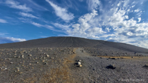
Hverfjall volcano
One of the most interesting attractions around the lake is the extinct volcano Hverfjall. The volcano is 462 m high. You can climb to its top to see a vast crater, which is over 1000 m wide and 140 m deep. From the top of the volcano, you can enjoy a beautiful view of the surrounding area.

Dimmuborgir – the black fortress
Near the crater, a route leads to a place whose name means “Black City” or “Black Fortress”. In the Dimmuborgir area, there are lava columns, caves and cliffs. Some rocks are up to 20 meters high. This area is a remnant of a lava lake, which has been active for 2,000 years. The Vikings believed that elves and trolls lived in these rocks. The area has several designated walking routes. Walking the shortest path takes approximately. 15 minutes, longer ones approx. 1 hour.
The rocks are brittle and easily damaged. The Falcons nest there, so you should stick to the designated routes and keep quiet to avoid spooking the birds.

- GPS coordinates: 65°35’14.99″ N -16°53’34.79″ W
Pseudocraters


When hot lava flows through wetlands or swamps, it creates explosive gases. The water vapour bubbles that form as they pass through the lava cause an explosion and create craters. They are often very similar to real volcanic craters, but their structures do not reach magma from within the Earth. That is why they are called “rootless cones.”


In Iceland, pseudocraters can be found in several places. However, the most spectacular ones are near Lake Myvatn, in the municipality of Skútustaðir. Other places in the world where you can observe pseudocraters are in the Azores, Hawaii and … on Mars. The last location may prove that there was once water on this planet.
Icelandic pseudocraters are a unique phenomenon on a global scale. They were created around 2,300 years ago. There is a walking path around the pseudocraters, so you can walk around them and look at some of them from the top. It is worth visiting this place while in Iceland.

- GPS coordinates: 65.567861, -17.034044
What else is worth seeing around the lake
There are also some other interesting places to visit in the area of Lake Myvatn. The Lake Myvatn website has all the news related to visiting the area and information about tourist attractions, accommodation and leisure activities.
Goðafoss Waterfall – Diamond Circle, top of the top
Goðafoss Waterfall (Waterfall of the Gods) is considered one of Iceland’s most spectacular waterfalls.

The river Skjálfandafljót falls here in three cascades from a height of 12-15 meters and a width of 30 meters. The entire surroundings of the waterfall are lava fields from the previous volcanic eruptions. On your way to Godafoss Waterfall from the parking lot on Road 1, you will pass the even smaller Geitafoss Waterfall (Goat Waterfall) and a pedestrian bridge was built in 1972.


Goðafoss attracts tourists and the island’s inhabitants due to its symbolic importance in the history of Iceland’s Christianization.
When Iceland converted to Christianity in 1000 AD, Þorgeir Ljósvetningagoði Þorkelsson was the then leader and member of parliament. According to the old sagas, although he was a pagan priest, he decided that all of Iceland must adopt one faith. He wanted to end the many disputes and fights between the followers of Christianity and Nordic paganism. When Þorgeir returned from the Althingi congregation – in a symbolic gesture of conversion – he got rid of the pagan gods by throwing their statues into a waterfall. Hence the name of the waterfall – Goðafoss, meaning Waterfall of the Gods.


How to get there
Goðafoss Waterfall is located on the National Ring Road No. 1, about 35 kilometres east of Akureyri. It is well visible from the main road. There are car parks on both sides of the waterfall: eastern and western.
The main car park is on the west side. However, most tourists and tour buses also park there, so it is often crowded.
- GPS coordinates of the parking lot on the west side: 65.684316, -17.548380
There are also several parking spaces on the eastern side. They are located next to the store, behind the N1 gas station. When we parked there (late afternoon in mid-July), the parking lot next to the store was completely empty. From here, the road to the waterfall will take you about 15-20 minutes one way.
It is also worth going down to the bottom of the gorge and looking at the Godafoss waterfall up close. Its size and power make a big impression when seen from this place.


Diamond Circle – places that must be seen
The name Diamond Circle means that many wonderful and diverse natural wonders are in close proximity—as precious as a diamond. The region is characterized by a large number of natural attractions, picturesque settlements, and fantastic landscapes. It’s definitely a one-day trip, and its close proximity to Akureyri makes it North Iceland’s most popular attraction.
Iceland, my other post
I encourage you as well to read my other posts about Iceland
- Akureyri – Northern Iceland
- East Iceland – the land of puffins
- Golden Circle – treasures of Iceland
- Húsavík, Iceland – time for whales
- Iceland – tailor-made travel plan
- Iceland in winter – how to organise the trip
- Iceland photos
- Reykjanes Peninsula, South West Iceland
- Reykjavik Iceland’s capital city
- Snaefellsnes Peninsula, West Iceland
- South Coast of Iceland
- Troll Peninsula North Iceland
- Winter in Iceland travel plan